Wieland, Ralf
Models
Other:
Fuzzy-model
Species distribution model
The global trade of goods (car tires and ornamental plants in particular) has facilitated the accidental transport of eggs, pupae and larvae of the Asian bush mosquito (Aedes japonicus japonicus) to North America and Europe. On both continents, the species has spread over wide areas and became established in several geographical regions. Since it is a potential vector of pathogens of humans and livestock, distribution and dissemination maps are urgently needed to implement targeted surveillance and control in case of disease outbreaks. Previous distribution models for Europe were relatively inaccurate because land-use effects remained unconsidered. Our approach is based on the fuzzy modelling technique combined with biological expertise that enabled to precisely define the interactions between the three most relevant factors determining the occurrence of this mosquito species: climate, wind and land-use. The model combines different spatial resolutions of data for Germany and achieves a much higher degree of accuracy than previous distribution models. Our results reveal that a well-suited landscape structure can even facilitate the occurrence of Aedes j. japonicus in a climatically unsuitable region. Vice versa, unsuitable land-use types such as agricultural landscapes and agroforests reduce the occurrence probability in climatically suitable regions. Our study demonstrates the importance of regional influences on propagation models for invasive mosquito species, in addition to global processes such as international trade and climate change.
Methods:
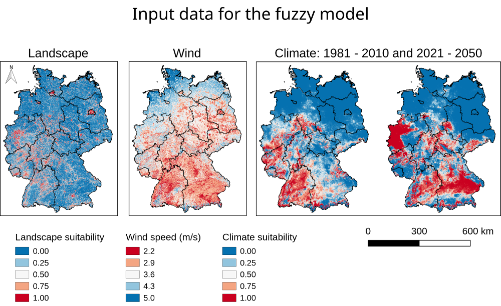
This data set contains results of the climate model, the landscape model and the fuzzy model. All results are saved as Ascii-Grid files in the standard raster position from the German Weather Service. The Coordinate System is DHDN 3-degree Gauss-Krüger Zone 3 (EPSG: 31467).
Climate model (1km x 1km resolution): This model processes the following data from the German Weather Service for the period of 1981-2010: Mean temperature in spring (T13)
Mean temperature in September (T9)
Mean temperature in October (T10)
Mean temperature in December (T12)
Sum of precipitation in February (P2)
Sum of precipitation in April (P4)
Sum of precipitation in June (P6)
Drought index of autumn (D15)
Forcast (climate suitability): The application of the climate model for the period 2021 to 2050 is based on the following assumption for the weather input variables: Change in annual mean temperature: +1.4°C (T9), (T10), T(12), T(13)
Change in winter precipitation: +5% [P2]
Change in summer precipitation: -4% [P6]
Landscape Model (resolution 100m x 100m): This model processes land cover data derived from the CORINE Land cover European seamless 100m raster database Version 18.5 (published in 2012) and several objects from the ATKIS (Amtliches Topografisch-Kartografisches Informationssystem) property data from 2008. In the model, values were assigned to the landscape categories which reflect their suitability as habitat for Aedes japonicus. With help of the mowing window technology, the mean value of each cell was calculated using its own and the neighbouring cell values within a distance of 700m.
Fuzzy model (resolution 100m x 100m): This model processes wind data (5m above ground, 200m x 200m resolution, derived from the German Weather Service) and data derived from the climate model and the landscape model. The fuzzy model was calculated twice, one time with the climate suitability of the years 1981-2010, and a second time with the climate suitability for the period of 2021-2050.
The fuzzy model was processed with the software SAMT2_fuzzy. Download under: https://github.com/Ralf3/samt2
Award number: BMEL-2819105315
Ministry of Science, Research and Culture of the Federal State of Brandenburg (MWFK)
ClimateSuitability_1981_2010.asc
ClimateSuitability_2021_2050.asc
FuzzyModel_run.py
FuzzyParameters.fis
ReadMe.txt
Result_Fuzzy_Model_1981_2010.asc
Result_Fuzzy_Model_2021_2050.asc
Result_Landscape_Model.asc
wind_100m.asc
Fuzzy model results