| DOI | |||||||||||||||||||||||||||||||||||||||
| https://dx.doi.org/10.4228/ZALF.DK.94 | |||||||||||||||||||||||||||||||||||||||
| Title | |||||||||||||||||||||||||||||||||||||||
|
A daily time-step observed and scenario climate dataset on a
European grid for crop modelling applications (version 2)
|
|||||||||||||||||||||||||||||||||||||||
| Creator(s) | |||||||||||||||||||||||||||||||||||||||
|
Fronzek,
Stefan ORCID: 0000-0003-2478-8050 Affiliation: Finnish Environment Institute (SYKE), Finland Webber, Heidi ORCID: 0000-0001-8301-5424 Affiliation: Leibniz Centre for Agricultural Landscape Research (ZALF), Germany Rötter, Reimund ORCID: 0000-0002-3804-9964 Affiliation: University of Göttingen, Germany Ruane, Alex ORCID: 0000-0002-5582-9217 Affiliation: NASA Goddard Institute for Space Studies, (GISS), USA Ewert, Frank Affiliation: University of Bonn, Germany; Leibniz Centre for Agricultural Landscape Research (ZALF), Germany |
|||||||||||||||||||||||||||||||||||||||
| Creator Institution | |||||||||||||||||||||||||||||||||||||||
|
Finnish Environment Institute (SYKE),
Finland Leibniz Centre for Agricultural Landscape Research (ZALF), Muencheberg (Germany) University of Göttingen, Germany NASA Goddard Institute for Space Studies, USA (GISS) University of Bonn, Germany; Leibniz Centre for Agricultural Landscape Research (ZALF), Germany |
|||||||||||||||||||||||||||||||||||||||
| Contributor Person | |||||||||||||||||||||||||||||||||||||||
| Contact Person: Fronzek, Stefan | |||||||||||||||||||||||||||||||||||||||
| Contributor Institution | |||||||||||||||||||||||||||||||||||||||
| Hosting Institution: Leibniz Centre for Agricultural Landscape Research (ZALF), Muencheberg (Germany) Data Collector: NASA Goddard Institute for Space Studies, USA (GISS) Data Collector: University of Göttingen, Germany Data Collector: University of Bonn, Germany Data Collector: Finnish Environment Institute (SYKE), Finland |
|||||||||||||||||||||||||||||||||||||||
| Description | |||||||||||||||||||||||||||||||||||||||
| Abstract: The data set contains daily time-step observed and
scenario climate data on a European grid with 25 km x 25 km spatial
resolution and is intended to be used for crop modelling
applications. The dataset covers the period 1980-2010 for
observations (for a baseline period of 1981-2010 and the year 1980
for crop model simulations with sowing dates in the autumn) and the
periods 2040-2069 and 2070-2099 for 5 GCMs x 2 forcing scenarios
(RCP4.5 and RCP8.5) and 2 GCMs with RCP2.6. The Joint Research
Centre’s (JRC) Agri4Cast gridded dataset was used for the baseline.
The scenarios have been calculated using an enhanced delta change
method that applies changes in aspects of temperature and
precipitation variability in addition to changes in mean climate.
Methods: The structure of the single tables refers to the gridcode of the model, for example the gridcode 35120 fits the location 35_120. This means the gridcode column is 120, the row 35. The explanation can be found in the properties of the kml file or the associated grid file. The data was generated by applying a “delta change factor” based on GCM outputs for RCP scenarios corresponding to the periods: 2040 until 2069 and from 2070 until 2099. As the “delta change factor” for these periods was applied to baseline observations for the period of 1.1.1980 to 31.12.2010, the dates for the respective scenario periods are still 1.1.1980 to 31.12.2010, due to the fact they are scenarios (ie, what would climate be relative to baseline climate). Pragmatically this avoids issues with different alignment of leap years between baseline and scenario periods. This is standard practice in climate data. Users of the data can adjust the dates as needed for their application. SeriesInformation: Two versions of the dataset are available: version 1 (DOI: https://www.doi.org/10.4228/ZALF.DK.59; consisting of 8709 grid cells) that was used by Webber et al. (2018) and an updated version 2 (this page - DOI: https://www.doi.org/10.4228/ZALF.DK.94; consisting of 8748 grid cells) that corrects an error when accounting for altitude differences to agricultural cultivation areas. It is recommended to use the latest version, unless the data of version 1 are intended to be used for direct comparison with the results of Webber et al. (2018), https://www.doi.org/10.1038/s41467-018-06525-2. | |||||||||||||||||||||||||||||||||||||||
| Related identifier | |||||||||||||||||||||||||||||||||||||||
| IsVersion: https://www.doi.org/10.4228/ZALF.DK.59 | |||||||||||||||||||||||||||||||||||||||
| Resource type | |||||||||||||||||||||||||||||||||||||||
| Dataset; table | |||||||||||||||||||||||||||||||||||||||
| Subject | |||||||||||||||||||||||||||||||||||||||
| AGROVOC: Crop modeling |
|||||||||||||||||||||||||||||||||||||||
| Date | |||||||||||||||||||||||||||||||||||||||
| Collected (start date): 01.01.1980 | |||||||||||||||||||||||||||||||||||||||
| Collected (end date): 31.12.2100 | |||||||||||||||||||||||||||||||||||||||
| Funding Reference | |||||||||||||||||||||||||||||||||||||||
| Award Number: 292836 (Academy of Finland) Award Number: 277403 (Academy of Finland) Award Number: 277276 (Academy of Finland) Funder Name: Finnish Ministry of Agriculture and Forestry Funder Name: Academy of Finland |
|||||||||||||||||||||||||||||||||||||||
| Language | |||||||||||||||||||||||||||||||||||||||
| english | |||||||||||||||||||||||||||||||||||||||
| Format | |||||||||||||||||||||||||||||||||||||||
| csv | |||||||||||||||||||||||||||||||||||||||
| Version | |||||||||||||||||||||||||||||||||||||||
| 2 | |||||||||||||||||||||||||||||||||||||||
| Publication Year | |||||||||||||||||||||||||||||||||||||||
| 2018 | |||||||||||||||||||||||||||||||||||||||
| Publisher | |||||||||||||||||||||||||||||||||||||||
| Leibniz Centre for Agricultural Landscape Research (ZALF), Muencheberg (Germany) | |||||||||||||||||||||||||||||||||||||||
| GeoLocation | |||||||||||||||||||||||||||||||||||||||
|
View Europe |
|||||||||||||||||||||||||||||||||||||||
| Structure of Data Table | |||||||||||||||||||||||||||||||||||||||
Table:
Climate_macsur_v2
|
|||||||||||||||||||||||||||||||||||||||
| Additional info | |||||||||||||||||||||||||||||||||||||||
|
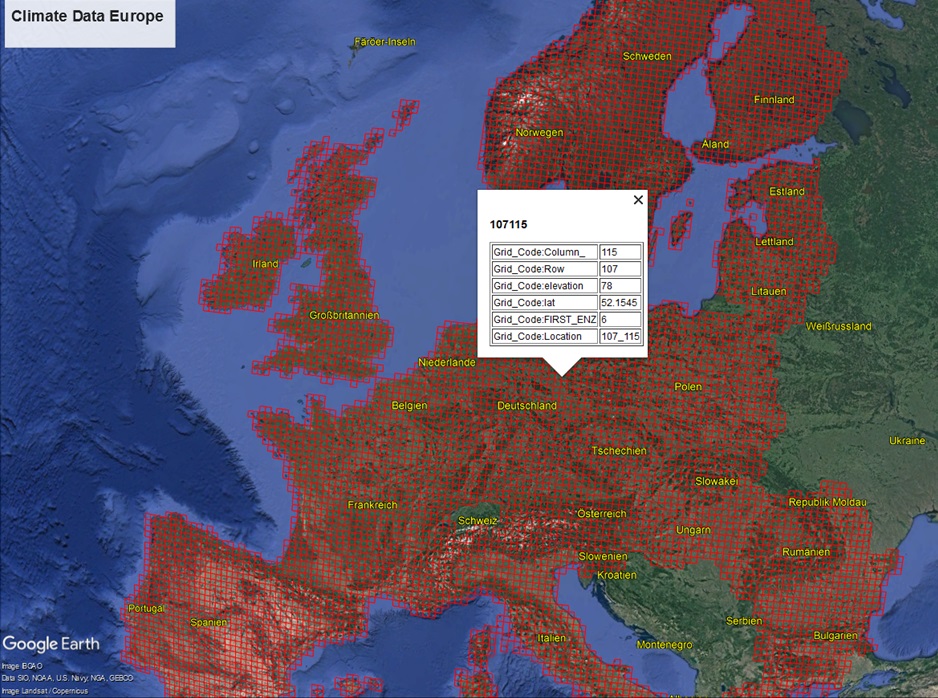
Data are stored as comma-separated values (csv) in one file per grid cell containing values for the baseline and all scenarios. Gridcell IDs are composed of the column and row numbers (see image below). Download is possible for individual grid cells or tar-packages containing files for a range of column numbers (i.e. defining a longitudinal band).
Please send to us name of your square name from Geolocation.
One single package contains one csv file (see above - Structure of
Data Table). The dataset consists of 8.748 dowloadable packages. Each package contain one single csv file with name of row + name of column. See image below. |
|||||||||||||||||||||||||||||||||||||||
 |
|||||||||||||||||||||||||||||||||||||||
| View Sample Data | |||||||||||||||||||||||||||||||||||||||
| Example_data | |||||||||||||||||||||||||||||||||||||||
| Download | |||||||||||||||||||||||||||||||||||||||
|
Download data If you have any questions please send an email to rda@zalf.de (subject DOI: 10.4228/ZALF.DK.94). Download grid cells and coordinates This file was added on Dec 12, 2019. Download missing data (grid cells and years with missing data in the JRC database) This file was added on Dec 12, 2019 |
|||||||||||||||||||||||||||||||||||||||
| Metadata on DataCite | |||||||||||||||||||||||||||||||||||||||
| go to Datacite | |||||||||||||||||||||||||||||||||||||||
| DataCite XML metadata | |||||||||||||||||||||||||||||||||||||||
| Download XML | |||||||||||||||||||||||||||||||||||||||
| Rights | |||||||||||||||||||||||||||||||||||||||
| This data by ZALF is licensed under the
Creative
Commons Attribution BY 4.0
|
|||||||||||||||||||||||||||||||||||||||